|
The Swampland Hidrography
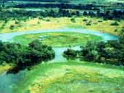
Hidrografy is the science that researches and maps all the
water surface of the Earth, showing the depth of the waters,
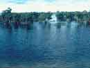
the speed and the direction of the currents. The Swampland
hidrography mesh is formed by the Paraguay River and their
largest tributaries are: São Lourenço (670 Km),
Cuiabá (650 Km), Miranda (490 Km), Taquari (480 Km),
Coxim (280 Km) and Aquidauana (565 Km), as well as the smaller
rivers: Nabileque, Apa and Black. The basin of the Paraguay
river is formed by 175 rivers that cover 1400 kilometers of
extension inside of the Brazilian territory. Due to this territorial
vastness and a favorable pluviometric condition our country
has the richest and most extensive hidrograpy net of the planet.
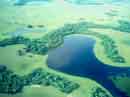
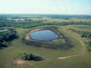
The Swampland is an immense flooded plain in constant movement,
varying with the flood times and drought, and four is the
factors that influence this formation: the geography, the
soil, the great number of rivers and the formations that involves
it. That area is plane, with altitudes that don't cross the
200 meter above the sea level and with an almost null steepness
favoring the floods along the Paraguay river, the only Swampland
canal. Surrounded by the Brazilian Plateau to east and for
the Andes Cordillera to west, these areas end up disemboguing
at that time of the flood or of their thaw waters in the Swampland,
this does with the soil is rich in clay impeding the absorption
of the water. That hidrography complex possesses bays, interlinked
lakes or not, denominatedfor corixos, ebb tides and small
temporary or permanent rivers. In the inundations the rivers
and stalls are interconnected, and in the ebb tide they are
enriched by the humus, the area becomes the largest and richer
concentration of natural foods that sustain the fauna and
the flora.
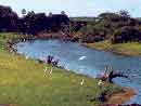
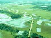
The Paraguay river is the main source of water provisioning
for the cities of Corumbá and Ladário, besides
being of fundamental importance for the rural activities.
The deficiency of superficial water in that area, did with
that most of the rural producers perforated artesian wells.
Most of these artesian wells of the area it was perforated
in calcareous rock, giving the "salty characteristic
water', waters with great concentration of carbonate of calcium
and magnesium. Studies indicated that in spite of that "salty"
characteristic, the salty water small risk of use and solidification
of the soil that water can be used to irrigate in the agriculture.
|
>>
Hidrovia Paraguai-Paraná


|